RCA received this email from an inquiring DC resident about the origins of Kramer Street, NE. There is some information available from the Rosedale Walking Historic Walking Tour RCA and CHRS presented back in May 2009. We have directed her to CHRS, but if anyone has information or can direct Sarah to other resources, either leave a comment or contact RCA (rosedaledc@gmail.com) and we'll gladly pass it along to her.
*******************
Hello,
My name is Sarah H. and I'm a recent graduate of GWU. I'm now a resident of DC and I'm trying to do some research (out of curiosity) on the origins of Kramer St. NE. I know it's in the Rosedale Neighborhood, and so I was wondering if you could give me any information, or point me in the direction of someone who could help me with this research. I've looked at historical maps and newspapers, and the earliest I've seen it in existence was 1900 as Kraemer St. I want to find out who the street is named after, or why it is named Kramer St. Anything you could do to help would be much appreciated!
Thanks so much,
Sarah
Showing posts with label Rosedale Historical Walking-tour. Show all posts
Showing posts with label Rosedale Historical Walking-tour. Show all posts
11.12.2009


7.28.2009
CHRS on the Rosedale Historic Walking-tour

HERE is the link to CHRS July/August 2009 Newsletter, the article is on pages 10 & 12.
Once again RCA would like to thank Beth Purcell (congratulations on becoming CHRS newest President!) and Donna Hanousek for all their time and effort in making the joint venture between CHRS and RCA a great success! And, a special thanks RCA members Dana Wyckoff and Frank Madrigal for all their hard-work too.
HERE is a previous post showing photos from the Rosedale neighborhood historical walking-tour.
6.03.2009
Rosedale Historical Neighborhood Walking -tour Photos - 1st Round

Tour Group begins at Rosedale Recreation Center, learns about Rosedale's origin and progression as the City of Washington, DC matures into a "Capitol City"

South-side, 1600 Block of Rosedale Street

South-side, 1600 Block of Rosedale Street

North Side, 1500 Block of Gales Street

North-side, 1600 Block of Rosedale Street

South-side, 1600 Block of Rosedale Street

North-side, 1500 Block of Gales Street

Beth (CHRS), Elizabeth (ANC6A), Necothia (RCA) and Donna (CHRS) at the 1600 Block of Rosedale Street

Dana Discusses Graceland Court Alley Dwellings (Demolished by the early 1960s) & Washington, DC Alley Life

North-side, 1600 Block of Kramer Street

Graceland Court (Between Gales St and Benning Rd), Once had Alley Dwellings (Demolished by the early 1960s)

South-side Kramer Street, Left house is original with a "pop-top" 3rd floor addition, the right house is a new infill building (notice the window locations and brick face patterns (see next photo)

South-side Kramer Street, Left brick field is original "Flemish bond" (structural exterior wall) and the right brick field is a new "running bond" (non-structural facade)

South-side, 1500 Block Gales Street

Gales Street, Tour Group Gathers to Learn about Graceland Court Alley Dwellings

North--side, 1600 Block of Kramer Street

South-side 1500 Gales Street, Wood Frame Duplexes are believed to be the first houses built in Rosedale (circa 1880s)

Tour Group walking along the north-side of 1600 Block Kramer Street

Tour Group along the south-side of Gales Street

Tour Group on the north-side of the 1600 Block of Kramer Street
5.22.2009
Rosedale Historic Walking Tour
Rosedale Citizens' Alliance (RCA) & Capitol Hill Restoration Society (CHRS) are proud to present:
A ROSEDALE NEIGHBORHOOD HISTORIC WALKING TOUR
“Rosedale's Hidden History – The Early Years”
“Please join us as we learn more about Rosedale’s early history, people and buildings. RCA & CHRS also welcome your memories and stories of Rosedale - so come along on the tour and add what you know, or contact us beforehand to tell us about Rosedale’s history and we’ll add it into the tour dialogue”
SATURDAY - MAY 30, 2009
• Tour promptly begins at 11AM at the corner of 17th & Gales Street, NE(Rosedale Recreation Center)

(click on map for a larger view)
• Light refreshments and a tour handout will be provided
• For general event information or to submit historical information about the Rosedale neighborhood, contact Dana - 571.213.1630 or rosedaledc@gmail.com
TOUR ROUTE INCLUDES
• 1600 block of Kramer St.
• 1600 block of Rosedale St.
• 1500 & 1600 block of Gales St.
HISTORICAL TOPICS INCLUDE*
Architectural History
• Building Styles
• Architects & Builders
Rosedale Neighborhood History
• Columbia Railway (trolley)
• Camp Barry - A Civil War Camp
• Original Land Owners
• Mamie ‘Peanut’ Johnson
Neighborhood Demographics & Social Fabric
• Profile of Early Residents
• Alley Dwelling Life
* Please note: this is neither a comprehensive history of the Rosedale community nor does it encompass the entire Rosedale neighborhood. The tour focuses on what CHRS believes, based on research, to be the oldest developed area of the Rosedale neighborhood. Our hope is this event inspires Rosedale residents to want more historic tours and participate in providing and collecting historic information about the neighborhood.
Below are few historic Rosedale neighborhood maps excerpted from larger historical maps retrieved from the David Rumsey Cartography Associates Map Collection.
The site has a fantastic base and overlay city map and GIS browser, check it out.

Rosedale Area circa 1851(click on map for a larger view)

Rosedale Area circa 1861(click on map for a larger view)

Rosedale Area circa 1862(click on map for a larger view)

Rosedale Area circa 1887(click on map for a larger view)

Rosedale Area circa 1897(click on map for a larger view)

Rosedale Area circa 1909(click on map for a larger view)
Below are excerpts from Baist's Surveys of Washington, Real Estate Atlas of the District of Columbia through Victorian Secrets of Washington, DC website.

Rosedale Area circa 1903(click on map for a larger view)
This area was extracted from 1903 Baist's Survey Map, Plate 31 - Click HERE to view the entire plate.

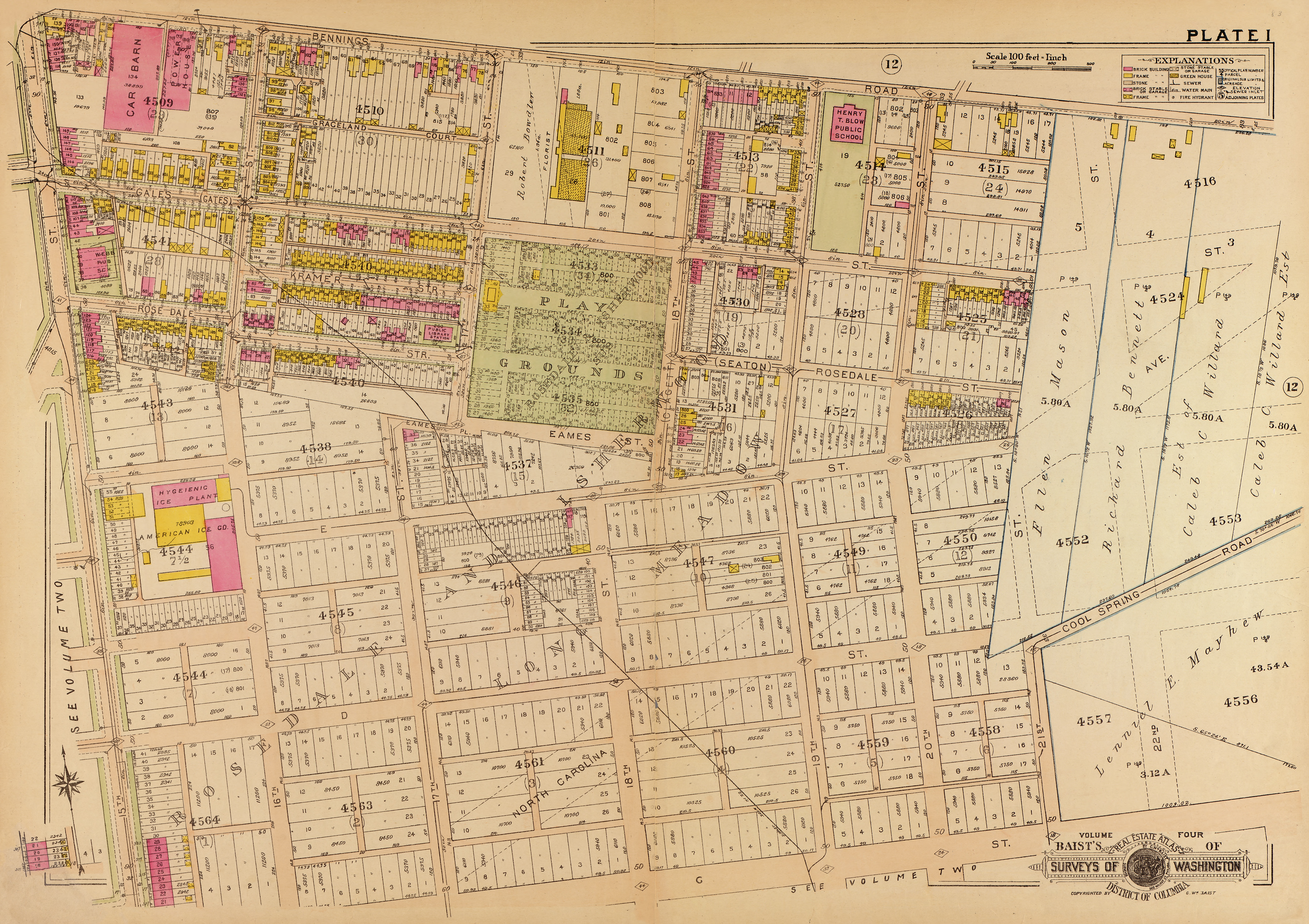
Rosedale Area circa 1919(click on map for a larger view)
This area was extracted from 1919 Baist's Survey Map, Sheet 1 Rosedale - Click HERE to view the entire sheet.
A ROSEDALE NEIGHBORHOOD HISTORIC WALKING TOUR
“Rosedale's Hidden History – The Early Years”
“Please join us as we learn more about Rosedale’s early history, people and buildings. RCA & CHRS also welcome your memories and stories of Rosedale - so come along on the tour and add what you know, or contact us beforehand to tell us about Rosedale’s history and we’ll add it into the tour dialogue”
SATURDAY - MAY 30, 2009
• Tour promptly begins at 11AM at the corner of 17th & Gales Street, NE(Rosedale Recreation Center)

(click on map for a larger view)
• Light refreshments and a tour handout will be provided
• For general event information or to submit historical information about the Rosedale neighborhood, contact Dana - 571.213.1630 or rosedaledc@gmail.com
TOUR ROUTE INCLUDES
• 1600 block of Kramer St.
• 1600 block of Rosedale St.
• 1500 & 1600 block of Gales St.
HISTORICAL TOPICS INCLUDE*
Architectural History
• Building Styles
• Architects & Builders
Rosedale Neighborhood History
• Columbia Railway (trolley)
• Camp Barry - A Civil War Camp
• Original Land Owners
• Mamie ‘Peanut’ Johnson
Neighborhood Demographics & Social Fabric
• Profile of Early Residents
• Alley Dwelling Life
* Please note: this is neither a comprehensive history of the Rosedale community nor does it encompass the entire Rosedale neighborhood. The tour focuses on what CHRS believes, based on research, to be the oldest developed area of the Rosedale neighborhood. Our hope is this event inspires Rosedale residents to want more historic tours and participate in providing and collecting historic information about the neighborhood.
Below are few historic Rosedale neighborhood maps excerpted from larger historical maps retrieved from the David Rumsey Cartography Associates Map Collection.
The site has a fantastic base and overlay city map and GIS browser, check it out.

Rosedale Area circa 1851(click on map for a larger view)

Rosedale Area circa 1861(click on map for a larger view)

Rosedale Area circa 1862(click on map for a larger view)

Rosedale Area circa 1887(click on map for a larger view)

Rosedale Area circa 1897(click on map for a larger view)

Rosedale Area circa 1909(click on map for a larger view)
Below are excerpts from Baist's Surveys of Washington, Real Estate Atlas of the District of Columbia through Victorian Secrets of Washington, DC website.

Rosedale Area circa 1903(click on map for a larger view)
This area was extracted from 1903 Baist's Survey Map, Plate 31 - Click HERE to view the entire plate.


Rosedale Area circa 1919(click on map for a larger view)
This area was extracted from 1919 Baist's Survey Map, Sheet 1 Rosedale - Click HERE to view the entire sheet.
2.06.2009
Meeting to Plan Rosedale Historical Walking -tour
Capitol Hill Restoration Society (CHRS) is planning to host a Rosedale neighborhood historical walking-tour for spring 2009!
All are welcome to join CHRS and RCA for the first planning meeting to discuss the event.
When: Saturday February 7 @ 2pm
Where: SOVA - 1359 H Street, NE, 202.397.3080
Hope to see you there!
All are welcome to join CHRS and RCA for the first planning meeting to discuss the event.
When: Saturday February 7 @ 2pm
Where: SOVA - 1359 H Street, NE, 202.397.3080
Hope to see you there!
Subscribe to:
Posts (Atom)